Route map
The AVL route map gives a clear and structured overview of the municipal bus network in one easy-to-read map.
Click below to view the general route map or the route map for night buses (CN1–CN8).
Information on how to read the map is provided below.
Interactive map
View the interactive map at maps.vdl.lu
Open mapThe lines
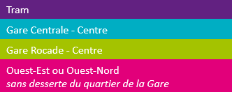
These core routes form the backbone of the transport network:
- Tram;
- Routes between "Gare Centrale" and the city centre;
- Routes between "Gare Rocade" and the city centre;
- West-East and West-North routes.
The bus network is completed by a system of secondary routes.

All buses on the blue line (travelling between Luxembourg Central Station and the city centre) stop at "Al Avenue" (on Avenue de la Gare) in both directions, while buses on the green line (travelling between "Gare-Rocade" and the city centre) only the stop at "Wallis" in both directions.
The "Hamilius" stop is the main transport hub in the city centre, served mainly by lines coming from or going to Luxembourg Central Station (blue lines) and "Gare-Rocade" (green lines), as well as the "West-East" and "West-North" routes (magenta lines).
Stops
Frequency
The thickness of the lines indicates the frequency of the buses:
- on the thick lines, buses come every 5–10 minutes;
- on the thin lines, buses come every 10 minutes or more.
Scale
Inside the grey frame in the centre of the map, the roads and routes are represented to scale and are topographically correct. Outside the grey frame, the map is more condensed, making it easier to read and understand.


