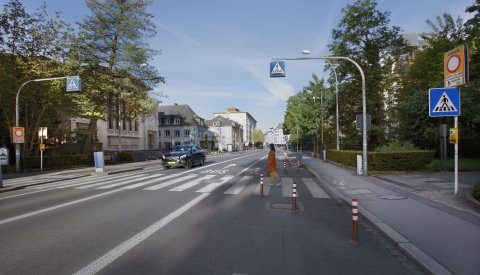
Pedestrian and bicycle crossings
At these specially marked crossings, pedestrians and cyclists have right of way over motorists. Here, cyclists can also cross the roadway using the cycle path (coloured red) without having to dismount. They must exercise caution in doing so, however.

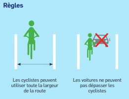
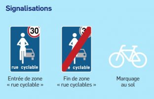
Shared contraflow lanes
Cyclists may ride counter to the flow of traffic in areas with speed limits of 30 km/h if road regulations for this area allow, as indicated by a special: "excepté cycles" (except cyclists) sign at the entrance to a one-way street.

Bus lane – authorised use by cyclists
Cyclists are only allowed to use the bus lane if a special "excepté cycles" (except cyclists) sign has been affixed under the bus lane sign.

Advanced stop line
At junctions controlled by traffic lights, the advanced stop line creates a waiting area for cyclists in front of the stop line for cars.
This allows cyclists to change lanes and position themselves visibly ahead of motorised vehicles so they can safely continue on their way when the traffic light changes.

Advisory lane
Advisory cycling lanes are intended for – but not reserved to – bicycle traffic, and are separated from the rest of the roadway by a broken line.
Cyclists do not have to use these advisory lanes and vehicles may use them if needed (at a crossroads, for example).
Indirect left turn
The indirect left turn is the safest way for a cyclist to make a left turn on major roads, which generally have junctions controlled by traffic lights.
Traffic lights for cyclists
Hop on your bike and enjoy safer and enjoy more fluid journeys, all the while adhering to rules of the road!
Sets of traffic lights around the city now have flashing amber lights for cyclists.
These lights allow cyclists to continue their journey in the direction of the arrow, even when light is red for vehicular traffic. Cyclists will nevertheless need to look out for other traffic and give way if necessary.
These lights have been installed at the following intersections:
- Avenue du Dix Septembre / Boulevard de Verdun
- Boulevard F.D. Roosevelt / Rue Philippe II
- Avenue Marie-Thérèse
- Boulevard F.D. Roosevelt (Rue de l'Ancien Athénée)
- Avenue Monterey / Boulevard Grande-Duchesse Charlotte
- Rue du Laboratoire
- Boulevard Joseph II, at the intersection of Allée Marconi and Place Winston Churchill
- intersection of Route d'Esch and Rue Marie-Adélaïde
- intersection of Bisserweg and Rue Munster
- intersection of Rue de Bonnevoie and Rue des Gaulois
- intersection of Rue d’Alsace and Rue Wenceslas 1er
- intersection of Rue de l’ancien Athénée and Boulevard F.D. Roosevelt.
Download
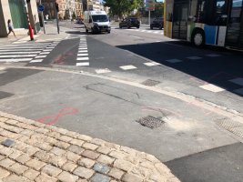
Detector loop
Several sets of traffic lights are now equipped with induction loops that detect the presence of bikes and reduce cyclists' waiting times at red lights.
To install these detectors, grooves are milled into the road surface, usually in the shape of a rectangle. The cables are then set into these grooves and connected to the traffic-light system for bikes. Once this is complete, the grooves are sealed.
When electricity flows through the newly installed cables, a magnetic field is generated. As soon as a bike, with its metal components, passes over or stops within the loop, changes in the magnetic field are detected. A signal is then sent to the traffic-light system, which in turn causes the light to change to green.
Images of a detector loop:


Bicycle boulevard
Bicycle boulevards are streets in the city that are reserved for cyclists. Their main purpose is to create safe, free-flowing routes between the major thoroughfares and existing cycling infrastructure.
The idea is to optimise existing routes used by cyclists, where vehicle traffic flows and interactions with motorists are very similar to those on a bicycle boulevard.
In introducing bicycle boulevards, the City can continue to gradually expand the network of bicycle routes and promote safe active travel options in the city.
The speed limit for motor vehicles on bicycle boulevards is 30 km/h.
The following are bicycle boulevards:
- Avenue Pasteur. On the section between Rue Batty Weber and Allée Scheffer.
- Rue de Bragance
- Rue Laurent Menager
- Rue de Pulvermühl
- Rue des Trévires – Rue Irmine – Rue J.-B. Gellé – Rue F. D'Huart – Rue Edouard Grenier. These roads are already part of Cycle Route n° 5 (Ban de Gasperich ó Ville Haute) that stretches across Bonnevoie, connecting Howald and Bonnevoie to the Gare district.
- Side lane of Rue du Laboratoire, which is already largely used as a cycle route.
- Rue d'Orange – Rue des Dahlias. These streets extend the existing cycle route on Rue de Bragance towards Belair, connecting Cycle Routes n° 9 (Merl ó Ville Haute), n° 10 (Belair ó Ville Haute) and n° 13 (Belair ó Gare).
- Val Ste Croix. This street connects Place de l'Étoile – one of the capital's major transfer hubs – to the PC1 national cycle route, which starts at Rue des Aubépines. It also creates an alternative to Route d’Arlon for cyclists as well as a bicycle connection to the neighbouring municipality of Strassen.
- Rue Godchaux. On the section between Rue Auguste Charles / Rue de Hamm and Gantebeensmillen, extending the existing bicycle boulevard to Rue de Pulvermühl.
- Rue de la Vallée. This street connects the cycle routes along Route d'Esch and Vallée de la Pétrusse.
- Rue Sosthène Weis. This one extends the existing bicycle boulevard on Rue Laurent Menager and forms a part of the PC1 national cycle route, crossing Pfaffenthal and connecting the districts of Eich and Pfaffenthal to Clausen and the Grund.


Bicycle and pedestrian traffic flow in the Municipal Park
To better accommodate foot and bicycle traffic, three types of lane have been created in the park: those reserved exclusively for cyclists, those reserved exclusively for pedestrians, and mixed lanes that can be used by both cyclists and pedestrians, based on a system of mutual respect.
There is now a two-way lane exclusively for cyclists (near Boulevard Prince Henri) between the intersection of Avenue de la Porte Neuve and Boulevard Prince Henri and the intersection of Avenue Marie-Thérèse and Boulevard Prince Henri. This path provides a safe and direct connection for cyclists between Kirchberg/Limpertsberg and the city centre/Gare district, as well as the Alzette valley via the elevator in the Pescatore Park.
With regard to pedestrians, the paths leading through the central areas of the Municipal Park are now reserved for people on foot, in particular in areas with high foot traffic (e.g. the "Pirateschëff" playground, area surrounding the Princess Amélie monument, etc.).
The thoroughfare that leads through the park on the side closest to Boulevard Joseph II and the east-west connections (alongside Avenue Marie-Thérèse, Avenue Émile Reuter and Avenue de la Porte-Neuve) are accessible to both cyclists and pedestrians, making it easier for all users to move around within the park.
Download


The latest guidelines for planning cycling infrastructure
To facilitate the planning of cycling infrastructure, the Ministry of Sustainable Development and Infrastructure (Ministère du Développement durable et des Infrastructures) has published a website, providing a number of fact sheets. These fact sheets contain the new set of recommendations on the development of different types of infrastructure for cyclists, and are meant to serve as a reference both when planning the cycle lane network and applying for building permits.
Currently, the existing fact sheets cover cycling infrastructure on standard road sections, but the site will regularly be updated to include information on crossroads, network planning, cycle parks, facilities in buildings catering to cyclists, etc.
If planners cannot find the information they are looking for in the fact sheets, they are welcome to develop their own ad hoc solutions. Such solutions must be duly justified, either by proving they comply with a regulation, standard or recommendation in force in another country, or by providing evidence of a successful pilot project or comparable existing development.
Queries, comments and suggestions should be forwarded to the Active Travel Unit (Cellule Mobilité Douce) of the Ministry of Sustainable Development and Infrastructure.
Link